Difference between revisions of "Sarawak"
| Line 1: | Line 1: | ||
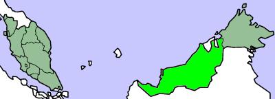
[[Image:sarawak_map.jpg]] | [[Image:sarawak_map.jpg]] | ||
| − | |||
| − | |||
| − | |||
| − | |||
| − | |||
| − | |||
| − | |||
| − | |||
| − | |||
| − | |||
| − | |||
| − | |||
Revision as of 19:34, 26 April 2009
Contents
Must See
National Parks
- Bako National Park - home to the bizarre, obscene-nosed proboscis monkey
- Bukit Lambir National Park - approximately 30km from Miri city. Known for its beautiful water falls and tranquility.
- Loagan Bunut National Park - home to the friendly community of Orang Ulu people known as the Berawan whom are mostly fishermen in this part of Sarawak. The largest freshwater lake in East Malaysia.
- Gunung Gading National Park - where you can try to spot a Rafflesia, the world's largest flower
- Gunung Mulu National Park - with mighty Mount Mulu and some of the world's largest cave system
- Kubah National Park - massive sandstone ridge with its three mountain peaks – the 911m high Gunung Serapi and the slightly smaller Gunung Selang and Gunung Sendok
- Tanjung Datu National Park - smallest of Sarawak’s National Parks, at just under 14 sq km, but it is also one of the most beautiful
- Talang-Satang National Park - was established with the primary aim of conserving Sarawak’s marine turtle population
- Batang Ai National Park - part of the region’s largest trans-national protected area for tropical rainforest conservation
- Similajau National Park - its coastline, a chain of golden sandy beaches, punctuated by small rocky headlands and jungle streams, and bordered by dense green forest
- Niah National Park - one of Sarawak’s better known national parks, important for its archaeological remains such as a 40,000 year old human skull, prehistoric cave paintings, and the birds nest industry. The caves are home to large colonies of bats and swiftlets.
waterfalls
- Bobak Falls - West of Kuching, near Kg Bobak
- Ban Buan Kukuot & Mabi - near Kg Sadir, 50 km south of Kuching
- Gunung Gading Falls - Near Lundu
- Latak Falls - Along the Bentulu-Miri road, 30 km from Miri
- Pantu Fall - Lambir Hills NP, 30 km from Miri
- Ranchan Falls - Near Serian
- Santubong falls - Santubong Peninsula, north of Kuching
- Skedu Fall - 50 km south of Kuching
rivers
- Lemanak - 220 km away from Kuching
- Skrang
- Rajang - the longest river in the whole of Malaysia, is the main "highway" connecting little towns and longhouses in Sarawak's hinterland.
islands
- Pulau Talang-Talang
- Semengoh - home to a famous orangutan sanctuary and rehabilitation center
- Wind Cave Nature Reserve - is part of the Bau Formation, a narrow belt of limestone covering about 150 sq km of Southwest Sarawak
- Sama Jaya Nature Reserve - the first multi-purpose urban forest park in Sarawak
- Sarawak Cultural Village
- Rainforest World Music Festival
- Iban Longhouse
Must Do
Must Eat
Cities
- Bintulu - dreary oil and gas industry base
- Kuching - Sarawak's capital, the City of Cats is located at the western tip of the state
- Belaga - Jumping point to many of inner Borneo's indigenous tribes and long houses
- Miri - Sarawak's northern city, capital of the state's oil industry
- Sibu - gateway to the hinterland of the Rejang River, Sarawak's and Malaysia's longest river
- Sarikei - "food basket" for the Land of the Hornbills
- Sri Aman - little town along the Batang Lupar, popular among local and foreign tourists especially during the annual tidal bore phenomenon 'benak' in April.
- Mukah - a coastal town in Central Sarawak where the sago-eating tribe (Melanau) are found.
- Kapit - one of the stopover along the Rejang and gateway to interior Sarawak
- Bintangor - former name is 'Binatang' meaning animal. Famous for greenish skin orange.
